
Power Platform
Public Group
Active 3 days ago
Power Platform
Organizer:
- JOSE Organized by
-
-
Zip Code/Post Code Map
-
Zip Code/Post Code Map
Posted by DSC Communities on July 15, 2019 at 1:00 am-

Daniel Demers
MemberJuly 15, 2019 at 1:00 AM
I’m wondering if anyone has successfully created a zipcode/postcode map in Power BI. My goal is to have a map similar to below (from Sydney Australia) with data that would be coming from a very basic data set with 5 columns of data (Country, State, City, Post/Zipcode, $$ sales amount). Is there a preferred add-on for this?I’ve tried many attempts but no luck so far.

——————————
Daniel Demers
Chief Digital Information Officer
Dan
61423566444
—————————— -
William Rodriguez
MemberJuly 15, 2019 at 9:36 AM
You have tried the ArcGIS maps?https://www.esri.com/en-us/arcgis/products/arcgis-maps-for-power-bi/overview
——————————
William Rodriguez
Business Analyst | MCSA: BI Reporting
——————————
——————————————- -
Daniel,
I used the ESRI map visual in Power BI to create this simple population by Zip code map. The two columns used are to the right.Tim
?
——————————
Tim Dyeson
Performance Measurement Manager
——————————
——————————————- -
I just did this last week! It was quite the effort to get it working, but eventually it worked.
There’s an option in Power BI Options called Preview Features. I selected the “Shape Map visual” and then was able to build my map from there. It requires a zip code JSON file, which I was able to find on a public repository on Github.
Good luck! I’m happy to answer any questions if you have them.
——————————
Alissa McBain
Business Intelligence Analyst
9163374590
——————————
——————————————- -
I was just looking at that shape map. Very interesting visual. Do you have the link to the zip code json file you used? I tried a couple different ones but it didn’t seem to work.?——————————
Sam Duval
46123
Indianapolis
3175245195
——————————
——————————————- -
It was my understanding that the files had to be Topo JSON files, and I found some US data here:
https://github.com/storiesofsolidarity/us-data/tree/gh-pages/geographyThere’s also some international data here:
https://github.com/deldersveld/topojsonThere’s some interesting information on TopoJSON here:
https://github.com/jgoodall/us-mapsand here:
https://github.com/topojson/us-atlasThis was definitely the hardest part of my project, finding the json file that I needed!
Good luck!
——————————
Alissa McBain
Business Intelligence Analyst
——————————
——————————————- -
Thanks for the links, works perfectly for mapping. Now only if the PBI devleopers would add the ability to add data labels to the map…?
——————————
Sam Duval
Data Quality Analyst
Indianapolis
——————————
——————————————- -
Robert Rund
MemberJanuary 29, 2020 at 5:06 PM
Thanks for posting these links. How did you connect the JSON file in Power BI ?in order to utilize these?
Thanks——————————
Robert Rund
——————————
——————————————- -
if you use the shape map visual, under settings, there is a section for new shape or map. It’s the same section that lets you change the built in maps
——————————
Sam Duval
Data Quality Analyst
Indianapolis
——————————
——————————————- -
Robert Rund
MemberJanuary 29, 2020 at 6:44 PM
Thanks for the response, I see that now. I still can’t figure out how to get that file imported into PBI though. Am I missing how to download the file or is there a way to import the JSON? I’m new to PBI so I’m not super familiar with JSON.?
Appreciate the help.——————————
Robert Rund
——————————
——————————————- -
You have to first make sure you have the actual topo JSON file downloaded, if you downloaded a zip you’ll have to extract it. then from there under options/settings (the little gear) under shape there is an option to add new map
——————————
Sam Duval
Data Quality Analyst
Indianapolis
——————————
——————————————- -
Eric Stephens
MemberMarch 15, 2020 at 9:29 PM
Alissa,Are the files you used (that you reference in your first link) actual TopoJSON files, or did you have to convert them to TopoJSON? I’m trying to do something for Tennessee so I download the following file (by clicking the Raw button then choosing Save As…not sure if that’s the right way but I’m not a master Github user).
https://github.com/storiesofsolidarity/us-data/blob/gh-pages/geography/zipcodes/Tennessee.geo.json
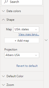
When I did this and then selected this file as the custom map in Power BI (with my numeric variable in the Color Saturation box), nothing rendered. It looks like it accepted the TopoJSON file as it’s allowing me to change the projection, but what I particularly noticed is that, when I click on ‘View map keys…’, nothing pops up, which indicates to me that something’s not connecting correctly. Any suggestions? I’ve uploaded the .pbix file I’m working on (which contains a functioning map using the ArcGIS map, but I don’t like it).
——————————
Eric Stephens
615-341-4465
——————————
——————————————- -
Priya Gupta
MemberNovember 26, 2020 at 5:09 AM
Hi ,
Thanks for sharing link. Actually i am using visual Drilldown Choropeth visual, where the requirement is for drill down in countries and 3digit zip code , for 3digit zip I i need the link of topojson ?file. Please can anybody help
——————————
Priya Gupta
——————————
——————————————- -
Thanks for sharing this data sources.
Actually, I need a json file for MapShape by US Zip Codes, and tried some sources but could not find what I need.
Could you let me know where to get it?Thanks!
——————————
Yunhee Bae
Data Analyst
——————————
——————————————- -
I think I have gotten the solution from the MS website where the solution for me is:
I have found that Power BI supports TopoJson format for Shape maps.
You may get the GeoJson file for US State Zip Code here and convert it to TopoJson format on the MapShaperThanks!
——————————
Yunhee Bae
Data Analyst
——————————
——————————————- -
Neville Howard
MemberJanuary 29, 2020 at 5:28 PM
Hi Daniel,good luck finding anything Australian related. I have managed to find a listing from Australia Post with lat and long for each Post Code. That might be helpful. The other responses look like they should help with which visual to use.
——————————
Neville Howard
Consultant
Brisbane
0732228400
——————————
——————————————- -
Dan Quigg
MemberJanuary 30, 2020 at 7:28 AM
Hi Daniel,I have used all of them – Mapbox is one you should definitely look at as well as ESRI. I would stay away from the Microsoft preview shape map. It is very limited and extremely slow (it can hang up your application). They have done nothing with it.
——————————
Dan Quigg
CEO
Public Insight
Hudson OH
330-656-9201
——————————
——————————————-
DSC Communities replied 6 years, 7 months ago 1 Member · 0 Replies -
-
0 Replies

Sorry, there were no replies found.
The discussion ‘Zip Code/Post Code Map’ is closed to new replies.